

CLIPS
How Texas Uses Live Flood Maps for Rescue
Billions on Fire Alarms, But What About Floods
How Real-Time Flood Forecasting Saves Lives
FLOODMAPP
Juliette Murphy, CEO and co-founder of Floodmapp joins us to continue the coverage of how the geospatial industry is responding to the flood season. This is after an episode with Shelly Klose about True Flood Risk a couple of weeks ago.

I should also highlight the episode on flood models with Fathom last year:

Juliette describes the capacity of her company to perform operational impact based flood forecasting. This is about using live data feeds such as from measures of precipitation, flood gauges, earth observation to provide a more accurate, real time estimate of where inundation will occur. Due to these factors, it will be better than, for example in the US, FEMA's 100 year flood polygons, for example:

As such, she was able to give examples from the State of Queensland in Australia where the system was used by emergency responders to decide where to send door knocking crews and also rescue personnel.
Products from the likes of First Street:

…and Fathom:
…will not be able to offer these real time directives on where to send first responders. This is because they are large scale risk models developed with variables like topography, climate and historical rainfall without real time data on rainfall in the moment. They cannot offer advice on where to evacuate people from, where emergency services should send boats and helicopters.
We are privileged to hear from her as they are involved now in the Texas flood clean up. She emphasised that they offer services in forecasting, 'nowcasting' and 'postcasting'. It is of course helpful to have assistance in characterising the inundation extent after a flood. This helps with helping where to look for damage and the deceased, along with verifying the risk modelling work of the likes of FEMA, Fathom and First Street.
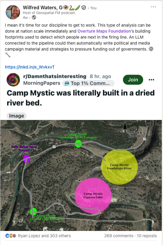
But one is forced to wonder how things would have gone if this or a similar service was involved in forecasting and early warning system activation for the area around Camp Mystic in Texas.
Speaking of which, it was good to have an expert like Juliette give her take on this viral post of mine in the moment as the implications of Camp Mystic spread across the internet:
Juliette had a simple directive - ‘by law … $USD8.7 billion has been spent just on [residential building] smoke alarms for fires… but what is the … investment in flood early warning systems? The economic damages from fire vs flood… it actually suggests that flood… is really far and above the cost … of fire. So I’d really like to see the expenditure on flood early warning systems reflect the risk. …if we’re investing this much on fire then we really need an alert system in every community where people are at risk’.
Emphasis mine.
Floods vs. Fires - The Case for Equal Investment
The analysis I proposed above is happening now. I face a very steep learning curve on cloud native geospatial tooling such as Wherobots but I am making progress with the help of Matt Forrest, Ryan Kmetz and Piergiorgio Roveda. The output will be a nationwide identification of the communities at risk. I look forward to Juliette’s assessment of that analysis.
